Population Data
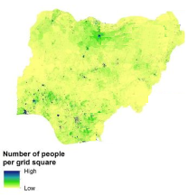
Population raster example
Each map needs a population raster. This can come from a default raster (WorldPop constrained and unconstrained are available) or else can be uploaded as well.
Get population data
Not unlike elevation data, population data usually come as a raster. In population rasters, each cell contains a population count: the number of people predicted to live in this particular raster cell. Population rasters may have several bands, representing different slices of the population: total population, male/female population, population of children under 5, etc.
Public and open global sources
Two main sources of public, open, up-to-date, high-resolution population rasters are currently available. They both offer datasets up to 100 m resolution, and both rely on models that aggregate multiple data sources to infer population distribution.
Local sources
If you need higher-resolution population data, higher precision, or population slices that are not offered by global sources, you could turn to local alternatives. Local population rasters are often based on census data, which often means higher spatial resolution and better accuracy. Beware though, that most countries do not conduct censuses very often, and that depending of the population dynamics of your AOI, local data could quickly become outdated.