Elevation Data (DEM)
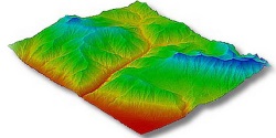
Digital Elevation Model example
A digital elevation model (DEM) is a digital model or 3D representation of a terrain’s surface created from terrain elevation data. In this catalog, three default sources of DEMs are available: ALOS30m, SRTM30m and FABDEM. More information and places where DEMs can be obtained:
SRTM (30m precision)
ALOS (30m precision)
PRISM data acquired by Japan Aerospace Exploration Agency (30m to 2m precision) (JAXA)
OpenTopography data (1m precision)
Any digital elevation data can be uploaded in a GeoTIFF format, as long as the size is under 2GB and the projection is in EPSG:4326.